The House Along the Allemaengel Road, Part 3
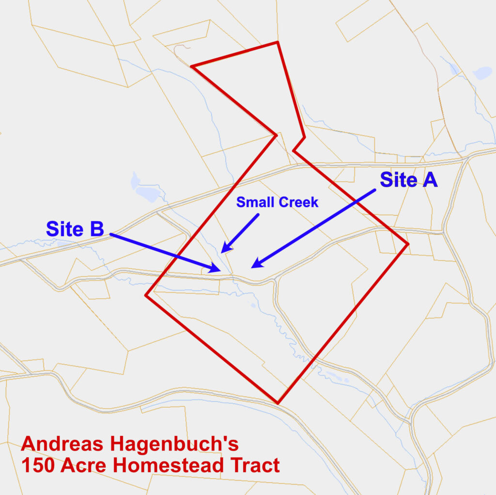
Where did Andreas Hagenbuch (b. 1715) build his house after settling upon the Hagenbuch Homestead property in 1741? For decades, my father, Mark, and I have pondered this question. In 2016, I summarized what we knew and presented our findings in a series of articles. Three theories were proposed:
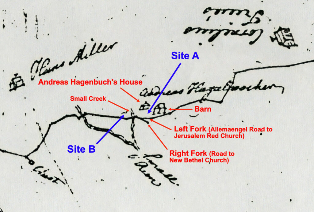
- Andreas’ house was situated where his great grandson, Michael (b. 1805), later built a stone farmhouse in 1851. This location was dubbed “Site A” in the previous series.
- Andreas’ home was one of the existing outbuildings near Michael’s stone farmhouse at Site A.
- Andreas’ house was built somewhere else entirely.
Eventually the first two theories were eliminated, leaving only the third. The series then went on to suggest that a neighboring parcel that once existed within the bounds of the Hagenbuch Homestead property was where Andreas built his home in 1741. The spot was labeled “Site B.” It lay approximately 300 feet to the west of Site A, just across a small creek. While it was clear that the house and barn on Site B were older than the house and barn on Site A, doubts remained about the exact age of Site B’s structures and if Andreas had constructed them.
No new evidence had emerged until earlier this year when we discovered Benjamin Lightfoot’s 1754 survey of the Allemaengel Road. The survey is fascinating for a number of reasons. First, it depicts the main road that the Hagenbuchs used to travel to and from their property during the 1700s. Next, it shows the Hagenbuchs’ neighbors and the location of their homes. Third, and most importantly, it describes where Andreas built his house and barn.
The survey of the Allemaengel Road was completed in two sections, and the Hagenbuch Homestead is visible on the second of these. The route started at Frederick Reichelderfer’s house near Eckville in Albany Township, Berks County, PA and ran east 7.8 miles to the Jerusalem Red Church, where it joined the first section of the road. The survey was recorded in two forms: a hand-drawn map and a written document with bearings and distances.
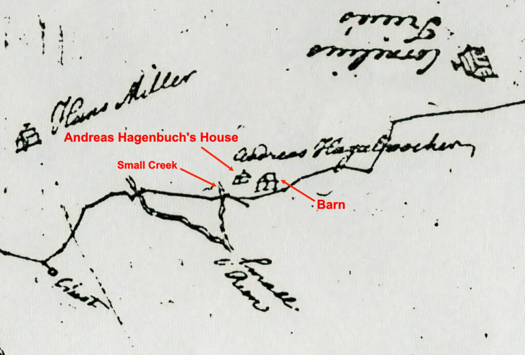
The map drawing makes it clear that the Allemaengel Road ran through the middle of Andreas Hagenbuch’s property and that his house and barn lay just to the north of it. Lightfoot placed a small chimney on the home to distinguish it from the barn. The drawing defines the relative size of the structures, illustrating that the barn was larger than the house. The house was located to the northwest of the barn and sat back from the road. Both buildings faced southeast.
But there was another detail that caused me to do a double take. The creek that flowed near Andreas Hagenbuch’s house had been recorded by Lightfoot and labeled as a “Small Run.” However, it was shown to the west of Andreas’ house. This contradicted my previous research which placed his home on Site B and the stream to the east. I considered the possibility that the creek had shifted several hundred feet to the east. After consulting a topographical map, I realized that it was nestled between two hills and could only have moved tens of feet in either direction. The implication of the stream’s position was obvious: Andreas had not built his house on Site B. He had placed it on Site A!
Thanks to Benjamin Lightfoot’s 1754 survey, I had a better idea of where Andreas Hagenbuch had constructed his home. Yet, where exactly at Site A was the house situated? To answer this question, I turned my attention to the survey document containing the bearings and distances for the second section of the Allemaengel Road. The text was straightforward enough, until it reached the part of the route that passed through the Hagenbuch Homestead property.

Portion of the survey text for the second section of the Allemaengel Road. The crossed out text reads: “26 Night @ 10 Andreas Hagabooch’s house Left 2 p.” Credit: Historical Society of Pennsylvania
Lightfoot noted that the road headed northeast to a “Run” (the creek) and continued one perch (16.5 feet) before turning southeast. He then recorded and subsequently crossed out the following line: “26 Night @ 10 Andreas Hagabooch’s house Left 2 p.” The text is ambiguous, but it seems to be saying that the road extended 26 perches to the southeast. At 10 perches along this distance, one must keep right (erroneously written as “Night”) and here Andreas Hagenbuch’s house can be seen on the left about two perches away—a terrific observation!
Still, for some reason Lightfoot discarded this portion of the road survey, backtracked, and redid his work. In his revisions, he wrote that this length of the road was only six perches long (instead of 26) and that it then turned due east for a distance of 21 perches. Why had Lightfoot made a mistake and what could it tell us?
Initially, I didn’t have a clue. I studied the survey map and text for several hours, going as far as to draw my own map of the Allemaengel Road using the recorded bearings and distances. I was getting nowhere quick. Finally, I spoke to my wife, Sara, and she made a brilliant observation. What had confused Benjamin Lightfoot was a fork in the road near Andreas Hagenbuch’s house—a junction that was later moved east during the 19th century. Lightfoot even showed the original configuration on his hand-drawn map. The right fork in the road continued to the southeast, while the left fork turned due east past the Hagenbuch’s house and barn. Lightfoot had missed the left fork, which was the correct route of the Allemaengel Road. Realizing his error, he backtracked and redid this part of the survey.
Lightfoot’s mistake is an invaluable resource for us today. It describes exactly where Andreas Hagenbuch’s home could be seen from the Allemaengel Road and corroborates that the smaller of the two buildings on the map was a house. If, as it appears, the map is an accurate depiction of the homestead, then we can see that the home sat back from the road, while the barn was right along it. Interestingly, this places the barn near a slope on the hill—a requirement for a banked barn.
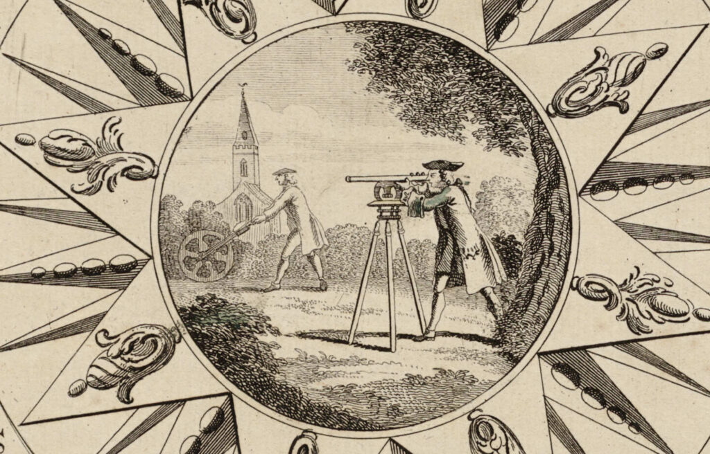
Illustration showing land surveyors working in the field. Taken from a 1748 map of Cornwall, England. Credit: lib.harvard.edu
As for Andreas Hagenbuch’s house, the map supports the theory that it was built at or near the site where his great grandson, Michael (b. 1805), constructed his stone farmhouse in 1851. After Michael’s father, Jacob (b. 1777), died in 1742 without a will, the homestead property was divided into three parcels. According to court documents, two of these contained homes: Site A and Site B. Michael acquired Site A with its existing home and 179 acres of land. Perhaps he and his family lived in his great grandfather’s old, log house until they could afford to build a new one?
And what of Site B with its house and barn? If this wasn’t built by Andreas in 1741, who constructed it and when? The most likely answer is that Site B was developed by Andreas’ son, Michael (b. 1746). In 1782, Michael purchased the entire homestead from his father, who had retired. Andreas died a few years later in 1785 and his wife sometime after that. They may have stayed in the original log home at Site A, while Michael (b. 1746) moved west across the creek to Site B and constructed a new house and barn for his growing tannery operation. Michael’s son, Jacob (b. 1777), eventually purchased the homestead in 1809 and lived at Site B until he died in 1842. The property was divided, and by the late 1800s the Hagenbuchs no longer resided at either Site A or Site B.
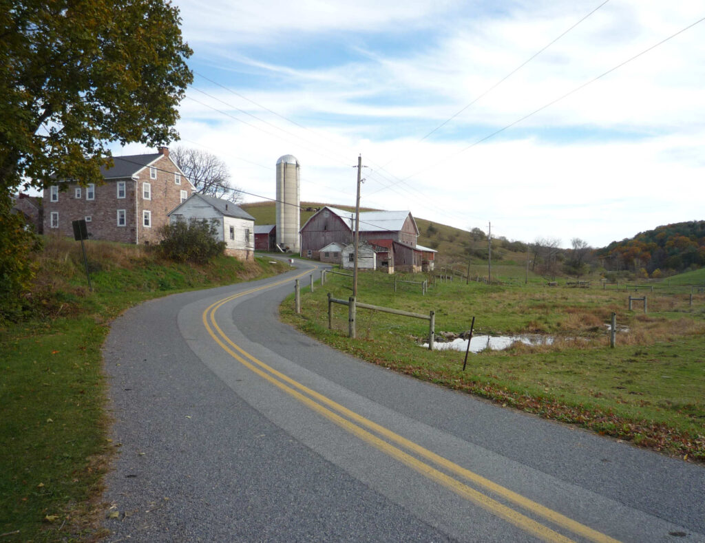
Looking east from where the Allemaengel Road would have crossed the small creek that separates Site A from Site B. Michael Hagenbuch’s 1851 farmhouse and barn are visible in this photo. Andreas Hagenbuch’s house would have been to the left of the stone farmhouse and set back from the road. The right fork in the road would have been on the right just before that barn.
From the moment I saw the 1754 drawing of the Allemaengel Road, I knew it would be an important document for our family. Presenting more than a simple road survey, the document depicts homes and other key landmarks throughout Albany Township, Berks County, PA. But most strikingly, it provides the strongest evidence yet for the location of Andreas Hagenbuch’s house and barn, helping us to further understand the the lives of our earliest ancestors.









Good Sleuthing! Now I’m ready and willing to go there with you and start an archeologic dig to find evidence of foundations for the house and barn!
Great report. I love this. Count me in with Robert Hagenbuch, Sr.
Great detective work. So glad that the Lightfoot map was the key.
So much more information that adds to my interest in my ancestry.
Have you done, I’m sure you have, on Samuel from whom I’m desended
Thank you for all your interesting work.
Linda
Hi Linda. Isn’t it great? So many more stories and people to investigate and uncover! My father wrote this piece on our site years ago. Back then I knew very little about our Harris connections: https://www.hagenbuch.org/samuel-susanna-hess-hagenbuch-family/ He also included the picture of Lydia (Hagenbuch) Stahl here: https://www.hagenbuch.org/photos-hagenbuch-family-archives-1/ This was later in this series which I think you read: https://www.hagenbuch.org/harrises-of-hidlay-part-2/