The House Along the Allemaengel Road, Part 2
The people living in the Allemaengel were fed up. The main route leading to and from their homes had fallen into such a state of disrepair that it was almost impassible. Haphazardly built when this corner of Albany Township, Berks County, Pennsylvania was settled in the 1740s, the road was rough, rutted, and blocked by encroaching fences.
Residents needed a fix—one that only the county could provide. So, on May 8, 1753 they petitioned the court at Reading, PA and asked the justices to lay out an improved road. Eventually, this thoroughfare would be known as the Allemaengel Road, and it would help travelers reach towns like Reading and Easton, as well as the city of Philadelphia.
In response to the petition, the Berks County justices appointed a surveyor named Benjamin Lightfoot (b. 1726, d. 1777). He was tasked with inspecting the existing route and defining a new, 50-foot-wide road. Lightfoot was the deputy surveyor for Berks County. Originally from Chester County, PA, he was Quaker and the son of Irish immigrants: Samuel Lightfoot (b. 1701) and Mary Head (b. 1703).
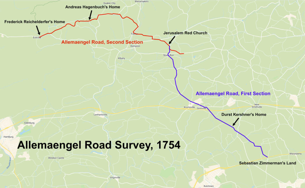
By early 1754, Benjamin Lightfoot had completed his survey of the Allemaengel Road, dividing it into two sections. The first ran southeast 6.8 miles from the Jerusalem Red Church in Albany Township to Sebastian Zimmerman’s property in Maxatawny Township. The second started at Frederick Reichelderfer’s house in Albany Township and ran east 7.8 miles to the Jerusalem Red Church, where it joined the first section of the route.
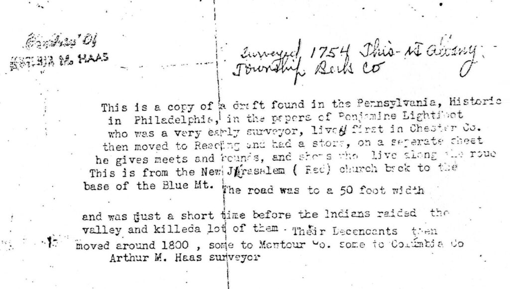
Arthur M Haas’ note on the photocopy of the 1754 survey of the second section of the Allemaengel Road
As explained in part one of this series, my father, Mark, and I recently found a photocopy of the second section of the Allemaengel Road. A note on the document suggested that it was made by Arthur M. Haas (b. 1904, d. 1986), a genealogist and surveyor from Lehigh County, PA. Haas probably had the photocopy made from Lightfoot’s survey map, while researching a piece he wrote about the Allemaengel Road for the Allentown Morning Call. His work was later published in 1966 under the column “‘S Pennsylvaanisch Deitsch Eck” (translation: The Pennsylvania Dutch Corner).
Photocopies are imperfect, high-contrast facsimiles. We wanted to trace Arthur Haas’ copy of the survey back to Lightfoot’s original in hopes of discovering additional details about the road and Andreas Hagenbuch’s (b. 1715) homestead. Thankfully, Haas noted the source of the survey on his copy: the papers of Benjamin Lightfoot within the collections at the Historical Society of Pennsylvania. The historical society is located in Philadelphia, and Haas must have visited there in the 1960s, viewed the original documents, and photocopied them.

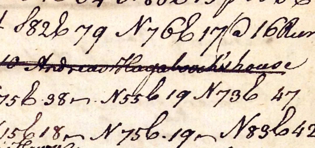
Portion of the survey coordinates for the second section of the Allemaengel Road. “Andreas Hagabooch’s house” is crossed out in black ink. Credit: Historical Society of Pennsylvania
With a citation in hand, my father and I made contact with a researcher at the Historical Society of Pennsylvania. We initiated a search for the 1754 survey of the Allemaengel Road. The hunt proved to be challenging. Benjamin Lightfoot’s papers are held within a larger collection of documents from the family—several of whom were surveyors. After a few months, a number of important documents were found including a drawing of the first section of the road and the survey coordinates for the second section. However, the map of the second section could not be found. This was discouraging to say the least.
Yet, there was one silver lining. Because we now had drawings for both parts of the Allemaengel Road—a scan of the first section and a photocopy of the second section—we could trace its route through present-day Berks County. As far as we know, this is the first time such a map has been created, enabling modern genealogists to approximate the path once traveled by our ancestors from the Allemaengel to Maxatawny.
While creating the map, the shape of the second section of the road caught my eye. Its route matched a mysterious, red line found on a drawing of the original land warrants within Albany Township. The document had been created in 2001 by John C. Robertson (b. 1957, d. 2018), and it depicted the shape of each warranted property along with the name of its first owner. John drew an unlabeled, red line running through the middle of the Hagenbuch Homestead. This was the Allemaengel Road.
I wondered: Had John Robertson seen Benjamin Lightfoot’s original surveys or did he obtain a photocopy of these from Arthur Haas’ previous work? Sadly, we will never know, since John died suddenly in 2018. My father and I had visited with him several times, as he was a well-known and respected historian from the Allemaengel. In fact, he lived on the homestead established by Adam Drumm (b. 1705, d. 1757). Drumm was a neighbor of Hagenbuchs, and his name appears on the 1754 survey map.
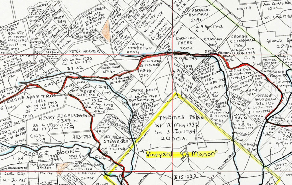
Section of John Robertson’s map of the original land warrants in Albany Township. Andreas Hagenbuch’s property is listed to the left of center. The red line going through the lot is the Allemaengel Road.
Things hadn’t gone as planned, and we were unable to locate Lightfoot’s original survey of the second section of the Allemaengel Road. Nevertheless, we had found enough documents to begin drawing conclusions. The third and final part of this series will take stock of what we have learned and explain what it reveals about the Hagenbuch Homestead.

